Watch: Icy start to week after UK sees weekend of snow
Passengers are facing cancellations and delays after several major airports in England had to shut their runways as snow and freezing rain swept parts of the UK.
An amber weather warning is still in place from the Midlands up to Carlisle. Less severe yellow weather warnings are also in force for parts of Scotland, Northern Ireland, Wales and elsewhere in England.
Until mid-morning on Sunday, no planes could leave Manchester Airport with all incoming flights being diverted elsewhere. Runways at five other airports were also temporarily closed.
Wintry conditions led to road closures and caused rail disruption and cancellations, while parts of south England have been warned of flooding.

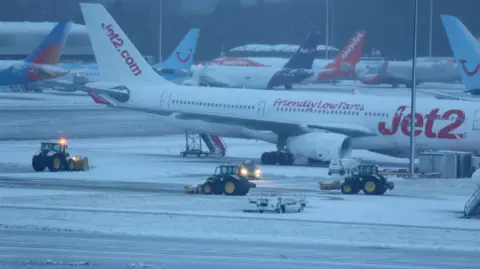 Reuters
Overnight snowfall caused Manchester Airport to close its runways
A number of flood warnings are in place across south England as a combination of heavy rain and melting snowfall means flooding is "expected" in these areas.
There are also more than a hundred flood alerts, which deem flooding "possible", in several areas of England and Wales.
By 16:00 GMT, flooding had caused rail delays in parts of southern England.
The Environment Agency said it is monitoring swollen rivers around the UK as some are near to bursting their banks.
The weather warnings in place are:
An amber warning for snow covering most central and northern England, including the Midlands and the north-west cities of Liverpool and Manchester, until midnight on SundayLess severe yellow warnings for snow covering parts of Scotland, Northern Ireland, Wales, and most of northern England including Leeds, Sheffield and the Lake District also until the end of the weekendAmber warnings are more serious than yellow warnings and indicate a possible risk to life, as well as more significant travel disruption.
Fresh yellow weather warnings will also come into force in some areas on Sunday and Monday.
There was 16cm (6.3in) of snow in Bingley, West Yorkshire as of 09:00 GMT on Sunday, while overnight the lowest temperature recorded was in Loch Glascarnoch, Scotland (-11C).
The Met Office has said some rural communities could be cut off, with up to 40cm of snow on ground above 300m, before conditions ease later on Sunday.
Overnight, snow is expected in north England as far south as the Peak District, in north Wales and southern and eastern Scotland.

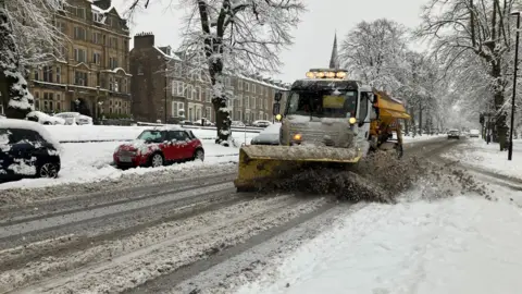 BBC/Yunus Mulla
Gritters have been out across the country - including in Harrogate in Yorkshire
Manchester Airport warned that "some departures and arrivals may still be subject to delays" after it was forced to close its runways, and urged passengers to check with their airline for updates on their flight.
Nearly 30 flights in and out of the airport have been cancelled and more than 250 delayed as of 17:15 GMT, according to tracking website FlightAware.
More than a dozen Manchester-bound planes have had to land at London Heathrow, Gatwick, Birmingham, Dublin, Glasgow and Paris.
As a result of heavy snowfall overnight, Liverpool, Bristol, Birmingham and Newcastle airports temporarily closed their runways. All have since reopened.
Leeds Bradford Airport reopened its runway shortly after 14:15 GMT but said disruption was expected throughout the day as it continued to mitigate heavy snowfall.
Overnight, snow closed the A628 Woodhead Pass, which connects Greater Manchester and South Yorkshire through the Peak District, in both directions between the A616 at Flouch and the A57 at Hollingworth.
The A66 in County Durham and Cumbria is closed between the M6 and A1M, while the A1 was closed southbound between the A639 North Elmsall and the A1(M)/A638 Doncaster in South Yorkshire due to a collision involving a car and a HGV, according to National Highways.
Stuart Irons, from National Highways, told BBC Breakfast on Sunday that 500 gritting lorries planned to be out across the UK and they have stockpiled more than 240,000 tonnes of salt as part of preparations.
He said: "Predominately it is snowing quite heavily in the north. The rest of the network is looking quite well, it is starting to ease from the Midlands down.
"But obviously as it does start to ease and it does thaw out there is a risk of flooding and there could be some freezing conditions later so we are advising motorists to be aware of areas with excess water."
In Merseyside, two safety meetings were held on Sunday morning to assess whether the snow and travel conditions would affect the Premier League clash between Liverpool and Manchester United.
The match was given the go-ahead, but Avanti West Coast said there would be limited trains going to or from Liverpool Lime Street station after all services were cancelled on Sunday morning due to issues at its depot.
National Rail said poor weather is affecting LNER, TransPennine Express and Northern services.
Meanwhile, melting snow caused disruption to rail networks in southern England, with delays expected until 18:00 GMT between London St Pancras International and St Albans.
Great Western Railway said heavy rain has flooded the line between Frome and Taunton, with trains running at reduced speeds.

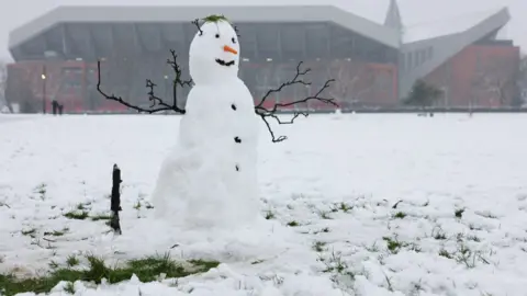 PA Media
A football match at Anfield stadium in Liverpool will go ahead
Through Saturday night into Sunday morning heavy snow affected much of England and northern Wales.
There is currently around 5cm of snow in many cities including Leeds and York, according to BBC Weather.
As of 16:30, heavy snow was still falling in Cumbria - with around 10cm already lying in Shap - in the far north of England, and across southern Scotland.
The heaviest snow is expected in higher parts of Wales, the Midlands and northern England, with up to 40cm possible over the mountains of north Wales, the Peak District and the Pennines.
At lower levels some disruptive snow is likely, but in places this will mix with rain - falling on cold surfaces, leading to the threat of ice.
Heavy rain and thawing snow could lead to flooding in some parts of England and Wales, while localised snow and ice warnings cover parts of Scotland, where it will remain cold.
Temperatures are forecast to dip again from Monday, and UK Health Security Agency (UKHSA) amber cold weather health alerts for all of England remain in place.
Additional reporting by Cachella Smith, Elizabeth Rizzini and Sofia Ferreira Santos

 Movie
Movie 3 months ago
108




![Presidents Day Weekend Car Sales [2021 Edition] Presidents Day Weekend Car Sales [2021 Edition]](https://www.findthebestcarprice.com/wp-content/uploads/Presidents-Day-Weekend-car-sales.jpg)


 English (United States)